La investigación geotécnica es un primer paso fundamental en cualquier proyecto de construcción, ya que sienta las bases de estructuras seguras y estables. Consiste en explorar las condiciones del subsuelo para conocer las propiedades del suelo y las rocas. Sin este proceso vital, los problemas imprevistos del terreno pueden provocar retrasos costosos, fallos estructurales y riesgos para la seguridad.
Esta guía definitiva profundizará en todos los aspectos de la investigación geotécnica de terrenos. Exploraremos las técnicas esenciales, el equipo y los análisis necesarios para recopilar datos cruciales sobre el terreno que se encuentra bajo su proyecto. Comprender estos fundamentos es clave para una construcción exitosa y resistente.
¿Qué es la investigación geotécnica?
Una investigación geotécnica es un proceso crítico en ingeniería civil y construcción que implica la evaluación de las propiedades físicas del suelo, la roca y las aguas subterráneas en un emplazamiento de construcción propuesto. Su objetivo principal es determinar la idoneidad de las condiciones del suelo para el uso previsto del terreno o la estructura.
Esta investigación proporciona datos esenciales sobre la resistencia del suelo, la capacidad portante, la estabilidad, la permeabilidad y la presencia de peligros potenciales como corrimientos de tierras, hundimientos o suelos expansivos. Los resultados orientan a los ingenieros en el diseño de cimentaciones, movimientos de tierras y sistemas estructurales generales adecuados para garantizar la seguridad, durabilidad y rentabilidad del proyecto de construcción.
¿Para qué sirve una investigación geotécnica del emplazamiento?
El objetivo principal de una investigación geotécnica del emplazamiento es evaluar sistemáticamente las condiciones del subsuelo de una obra propuesta con el fin de recopilar información esencial para un diseño y una construcción seguros, económicos y sostenibles. Este proceso ayuda a los ingenieros a comprender cómo interactuará el terreno con la estructura proyectada, identificar los riesgos potenciales y fundamentar las decisiones críticas de ingeniería.
- Determinar las propiedades del suelo y las rocas: Identificar el tipo, la resistencia, la densidad y otras características de ingeniería de los materiales del suelo presentes a distintas profundidades, cruciales para el diseño de los cimientos.
- Evaluar la capacidad portante: Evaluar la carga máxima que el suelo puede soportar con seguridad sin asentamientos excesivos, informando del tipo y tamaño de los cimientos necesarios.
- Identificar los riesgos geológicos: Detectar problemas potenciales como pendientes inestables, susceptibilidad a la licuefacción, suelos expansivos, socavones o fallas que puedan afectar a la estabilidad del proyecto.
- Localizar los niveles de agua subterránea: Determinar la profundidad y las fluctuaciones del nivel freático, lo que es fundamental para las estrategias de desagüe, el diseño de los cimientos y la evaluación de la posible flotabilidad o contaminación de las aguas subterráneas.
- Guía de diseño de cimentaciones: Proporcionar los datos necesarios para seleccionar el sistema de cimentación más adecuado y rentable (por ejemplo, zapatas poco profundas, pilotes profundos, balsas) para las cargas previstas y las condiciones del emplazamiento.
- Optimizar los métodos de construcción: Informar las decisiones sobre técnicas de excavación, requisitos de movimiento de tierras, medidas de estabilidad de taludes y posibles necesidades de mejora del terreno, lo que conducirá a una construcción más eficiente.
- Garantizar el cumplimiento de la normativa: Proporcionar la documentación exigida por los códigos de construcción y los organismos reguladores, demostrando que el diseño del proyecto se basa en principios geotécnicos sólidos y cumple las normas de seguridad.
¿Por qué es importante la investigación geotécnica?
La investigación geotécnica es un paso fundamental en cualquier proyecto de construcción, ya que proporciona información crucial sobre las condiciones del subsuelo. Conocer el terreno bajo una estructura es fundamental para la seguridad, la estabilidad y el rendimiento a largo plazo.
Mitigación de riesgos
Las investigaciones geotécnicas son vitales para identificar y mitigar los posibles riesgos geológicos que podrían comprometer un proyecto de construcción. Esto incluye la detección de capas de suelo inestables, la presencia de aguas subterráneas, riesgos de actividad sísmica o el potencial de deslizamientos y hundimientos. Al conocer estos riesgos de antemano, los ingenieros pueden aplicar las modificaciones de diseño adecuadas, técnicas de mejora del terreno o estrategias de mitigación, evitando costosos fallos, retrasos y garantizando la seguridad tanto de la estructura como de sus ocupantes.
Diseño optimizado y rentabilidad
Unos datos geotécnicos precisos permiten a los ingenieros diseñar cimentaciones y elementos estructurales adaptados con precisión a las condiciones específicas del terreno. Esta optimización evita tanto los diseños excesivamente conservadores, que pueden generar costes de material y construcción innecesarios, como los diseños insuficientes, que pueden provocar inestabilidad estructural y futuras reparaciones. Un diseño bien fundamentado y basado en una investigación exhaustiva permite un uso eficiente de los recursos, una reducción del tiempo de construcción y un importante ahorro de costes a largo plazo.
Cumplimiento de la normativa y seguridad
La realización de una investigación geotécnica exhaustiva suele ser un requisito obligatorio para obtener permisos de construcción y garantizar el cumplimiento de los códigos de construcción locales y nacionales. Estas investigaciones proporcionan la documentación necesaria para demostrar que la construcción propuesta cumple las normas de seguridad y los reglamentos medioambientales. En última instancia, una evaluación geotécnica exhaustiva contribuye directamente a la seguridad general del proceso de construcción y de la estructura terminada, protegiendo a los trabajadores y al público.
Rendimiento y durabilidad a largo plazo
La información obtenida de una investigación geotécnica es crucial para predecir cómo interactuará el suelo con la estructura a lo largo de toda su vida útil. Comprender factores como las características del asentamiento, la interacción suelo-estructura y el potencial de erosión ayuda a diseñar para una durabilidad a largo plazo y minimizar las necesidades de mantenimiento. Este enfoque proactivo garantiza que la estructura permanezca estable y funcional durante décadas, salvaguardando su valor y evitando el deterioro prematuro.
Tipos de investigación geotécnica
Las investigaciones geotécnicas abarcan varios tipos, cada uno adaptado a las necesidades específicas del proyecto y a las condiciones del emplazamiento. Estos enfoques garantizan una recopilación de datos exhaustiva para la toma de decisiones de ingeniería fundamentadas.
Investigación preliminar
Una investigación preliminar, también conocida como estudio documental o reconocimiento, es la fase inicial de la evaluación de la idoneidad geotécnica de un emplazamiento. Consiste en revisar los mapas geológicos existentes, las fotografías aéreas históricas, los registros de construcciones anteriores y los registros de pozos locales para recopilar la información disponible sobre las condiciones del subsuelo.
También se realizan observaciones de la superficie y un recorrido visual del emplazamiento para identificar características obvias como patrones de drenaje, estructuras existentes y peligros potenciales. Esta fase ayuda a formular un alcance detallado para las investigaciones posteriores, más invasivas, identificando los posibles problemas con antelación y orientando la selección de los métodos de perforación y ensayo adecuados.
Investigación detallada
Una investigación detallada es una evaluación completa y en profundidad que se realiza después de la fase preliminar, una vez que el proyecto está más definido. Este tipo implica un extenso trabajo de campo, que incluye la perforación de numerosos sondeos, la excavación de pozos de prueba y la realización de una amplia gama de pruebas in situ (por ejemplo, SPT, CPT, DMT) para recopilar datos precisos del subsuelo.
Se extraen numerosas muestras de suelo y roca para su análisis exhaustivo en laboratorio con el fin de determinar las propiedades de ingeniería detalladas. El objetivo es recopilar toda la información necesaria para el diseño final de cimentaciones, movimientos de tierras y otras estructuras geotécnicas, proporcionando una sólida comprensión del complejo comportamiento del suelo bajo las cargas propuestas.
Investigación complementaria
Se realiza una investigación complementaria cuando se necesitan datos geotécnicos adicionales durante o después de la investigación detallada principal. Esto suele ocurrir debido a condiciones imprevistas del terreno encontradas durante la construcción, cambios en el diseño del proyecto o la necesidad de abordar cuestiones específicas que no se resolvieron completamente en fases anteriores.
Puede consistir en perforaciones selectivas, pruebas específicas in situ o análisis de laboratorio especializados centrados en zonas problemáticas concretas o en modificaciones del diseño. Este tipo de investigación es crucial para abordar los retos emergentes, validar los supuestos y garantizar la seguridad y estabilidad continuas del proyecto.
Perforación e investigación geotécnica
Perforación geotécnica es el proceso básico de obtención de información del subsuelo para la investigación de obras. Consiste en perforar el terreno para extraer muestras y realizar ensayos in situ, lo que proporciona datos directos sobre las propiedades del suelo y las rocas, cruciales para una construcción segura y eficiente.
Perforación rotatoria
La perforación rotatoria es un método versátil y muy utilizado en investigaciones geotécnicas, sobre todo para perforar a través de diversas formaciones de suelo y roca. Esta técnica utiliza una broca giratoria para cortar y pulverizar material en el fondo de una perforación.
A continuación, los recortes de perforación se llevan a la superficie haciendo circular un fluido de perforación (como agua, aire o lodo de perforación) a través de la tubería de perforación y el anillo. Este método es eficaz para obtener muestras continuas de roca y muestras inalteradas de suelos cohesivos, por lo que resulta adecuado para exploraciones profundas.
Perforación con barrena
La perforación con barrena es un método habitual y eficaz, especialmente para investigaciones geotécnicas poco profundas en suelos cohesivos y formaciones rocosas blandas. Consiste en hacer girar en el suelo una barrena helicoidal en forma de tornillo que lleva el material excavado a la superficie.
Se utilizan tanto barrenas de vástago macizo (para el muestreo continuo) como barrenas de vástago hueco (que permiten el muestreo y las pruebas in situ a través del núcleo hueco sin retirar la sarta de barrenas). Este método es relativamente rápido y rentable, pero menos eficaz en arenas no consolidadas o fluidas.
Perforación por percusión
La perforación por percusión, también conocida como perforación con herramienta de cable, consiste en levantar y dejar caer repetidamente una herramienta de corte pesada (una broca) en el pozo. El impacto rompe el suelo o la roca, y el material aflojado se retira con un achicador.
Este método de perforación es especialmente eficaz para perforar a través de roca dura, grava y cantos rodados, donde otros métodos podrían tener dificultades. Aunque es más lenta que la perforación rotatoria, puede producir muestras muy precisas y se utiliza a menudo para instalaciones de pozos de control de aguas subterráneas.
Perforación por empuje directo (DP) o geosonda
La perforación por empuje directo (DP) o geosonda consiste en empujar hidráulicamente herramientas y sensores de pequeño diámetro directamente en el suelo sin rotación ni retirada de recortes. Este método es muy eficaz para el perfilado rápido del subsuelo, las investigaciones medioambientales y la obtención de muestras de suelo y aguas subterráneas a profundidades de someras a moderadas en suelos no consolidados. Minimiza la alteración del suelo y genera un mínimo de residuos, lo que lo convierte en una alternativa "más limpia" para muchas evaluaciones de emplazamientos.
Perforación con corona
La perforación con corona es un tipo específico de perforación rotatoria diseñada para extraer muestras cilíndricas intactas (núcleos) de roca o suelo muy duro. Se utiliza un barril sacanúcleos impregnado de diamante o con punta de carburo que corta un anillo anular en la formación, dejando un núcleo sólido en el interior. Este método proporciona muestras de la máxima calidad para el análisis detallado en laboratorio de las propiedades de la roca, incluidas la resistencia, la discontinuidad y la permeabilidad, cruciales para el diseño de cimentaciones en lecho rocoso.
Equipo de perforación para investigación geotécnica
Los equipos de perforación son los caballos de batalla de la investigación geotécnica, ya que permiten acceder a los materiales del subsuelo para tomar muestras y realizar ensayos in situ. Su selección es fundamental, ya que depende de las condiciones del emplazamiento, la profundidad de perforación necesaria y el tipo de formaciones geológicas encontradas.
Perforadoras sobre camión
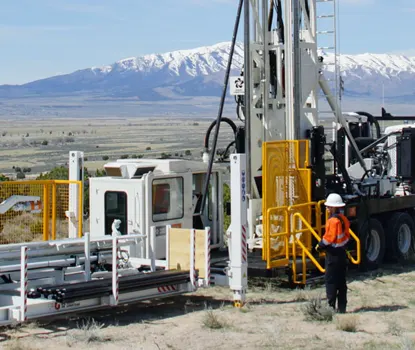
Los equipos de perforación montados en camiones son muy versátiles y se utilizan ampliamente en investigaciones geotécnicas gracias a su movilidad y potencia. Estos equipos se montan directamente sobre el chasis de un camión, lo que permite un rápido despliegue en diversos emplazamientos, incluidos aquellos con un acceso relativamente bueno por carretera. Son capaces de realizar una amplia gama de técnicas de perforación, como la perforación con barrena, la perforación rotatoria y la extracción de testigos, lo que los hace adecuados para diversas condiciones del suelo y la roca. Su carácter autónomo y su capacidad para transportar las herramientas y el agua necesarios contribuyen a la eficacia del trabajo de campo.
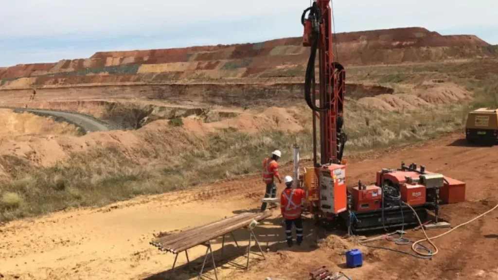
Taladros sobre orugas
Los equipos de perforación sobre orugas están diseñados para ofrecer una maniobrabilidad y estabilidad superiores en terrenos difíciles. Equipadas con orugas de goma o acero, estas perforadoras pueden acceder a terrenos remotos, irregulares o blandos a los que no pueden acceder los vehículos de ruedas. Su baja presión sobre el suelo reduce al mínimo la perturbación de lugares sensibles, mientras que su robusta construcción permite realizar perforaciones profundas y manipular formaciones geológicas difíciles. Suelen utilizarse en regiones montañosas, humedales o lugares de acceso limitado.
Equipos de perforación montados en vehículos todo terreno (ATV)
Los equipos de perforación montados en ATV son compactos y ligeros, y están diseñados específicamente para zonas de acceso muy restringido o sensibles desde el punto de vista medioambiental. Estos equipos pueden transportarse en helicóptero o desmontarse para su transporte manual, lo que los hace ideales para zonas remotas, bosques densos o pendientes pronunciadas. A pesar de su reducido tamaño, son capaces de utilizar diversos métodos de perforación, como la barrena y la perforación con corona de diamante, proporcionando información esencial sobre el subsuelo en lugares en los que los equipos de mayor tamaño resultan poco prácticos.
Taladros portátiles
Los equipos de perforación portátiles son la opción más compacta y ligera, ya que están diseñados para desmontarse en pequeños componentes que pueden transportarse a mano. Esto los hace indispensables para investigaciones en lugares extremadamente remotos e inaccesibles, o en zonas protegidas desde el punto de vista medioambiental donde ni siquiera pueden operar los vehículos todoterreno. Aunque su profundidad y potencia de perforación son limitadas en comparación con equipos más grandes, son cruciales para obtener muestras críticas y realizar pruebas in situ poco profundas en terrenos difíciles.
Taladros helitransportables
Los equipos de perforación helitransportables son equipos especializados diseñados para ser transportados en helicóptero, lo que permite acceder a los lugares más remotos y difíciles donde no es posible acceder por tierra. Estos equipos son modulares y se dividen en componentes que se adaptan a las eslingas de carga de los helicópteros. Ofrecen importantes capacidades de perforación, incluida la perforación profunda de rocas, lo que las hace esenciales para proyectos de infraestructura a gran escala en regiones montañosas o subdesarrolladas donde el acceso tradicional es imposible.
Pasos de la investigación geotécnica
Una investigación geotécnica sigue un proceso sistemático para evaluar a fondo las condiciones del subsuelo, garantizando la recopilación y el análisis exhaustivos de datos para tomar decisiones de ingeniería sólidas. Cada paso se basa en el anterior y conduce a un conocimiento sólido del emplazamiento.
Etapa 1: Planificación y definición del alcance
Las investigaciones geotécnicas eficaces comienzan con una meticulosa planificación y delimitación del alcance. Esta fase inicial implica definir claramente los objetivos de la investigación, que se adaptan a los requisitos específicos del proyecto, como el diseño de cimientos, el análisis de estabilidad de taludes o el control de aguas subterráneas. Los ingenieros determinan meticulosamente el alcance necesario de las pruebas, teniendo en cuenta factores como el tamaño del emplazamiento, su complejidad, las cargas y tolerancias estructurales propuestas y cualquier restricción reglamentaria o medioambiental pertinente.
Además, esta fase incluye consideraciones logísticas cruciales. La planificación aborda las dificultades de acceso al emplazamiento, sobre todo en lugares remotos o restringidos que podrían requerir equipos de perforación especializados y portátiles. También se da prioridad a los protocolos de seguridad, que incluyen evaluaciones de riesgos potenciales como la proximidad a servicios públicos existentes o la presencia de materiales peligrosos, garantizando el bienestar del equipo de investigación.
Paso 2: Evaluación del emplazamiento
El segundo paso consiste en un reconocimiento inicial del emplazamiento, una evaluación preliminar crítica para identificar los factores geológicos y medioambientales clave. Los geólogos e ingenieros realizan inspecciones minuciosas de la superficie, observando características tales como afloramientos visibles del suelo, patrones de drenaje existentes y tipos de vegetación, que pueden proporcionar pistas valiosas sobre las condiciones del subsuelo. Estas observaciones preliminares suelen indicar la presencia de características específicas del suelo, como suelos débiles o expansivos, antes de iniciar cualquier prueba invasiva.
Durante esta fase, también se identifican los posibles riesgos geológicos en una fase temprana del proceso. Esto incluye la evaluación de los riesgos derivados de la actividad sísmica mediante la cartografía de las fallas y las zonas de licuefacción, las pruebas de contaminación del suelo que podrían afectar a la construcción o requerir remediación, y la evaluación del riesgo de deslizamientos de tierra en terrenos accidentados o montañosos. En esta fase, los estudios sobre el terreno se complementan a menudo con la revisión de datos históricos, el análisis de imágenes aéreas y la utilización de cartografía geoespacial para obtener una comprensión holística de la historia y el estado actual del emplazamiento.
Paso 3: Trabajo de campo
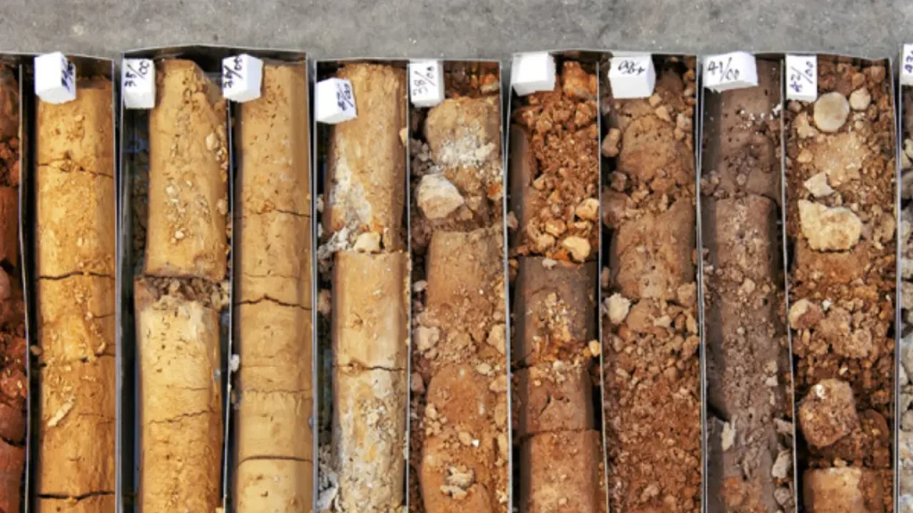
El trabajo de campo constituye la espina dorsal de las investigaciones geotécnicas e implica diversas técnicas para recopilar datos directos del subsuelo. Esto incluye principalmente la perforación de pozos en ubicaciones y profundidades estratégicas, determinadas por el tamaño del emplazamiento y los requisitos específicos del proyecto. De estas perforaciones se extraen meticulosamente muestras de suelo y roca a diferentes profundidades, que proporcionan especímenes físicos para su análisis detallado en laboratorio.
También se realizan ensayos in situ para obtener datos en tiempo real sobre el comportamiento del suelo en condiciones reales. Entre los métodos habituales se incluye el ensayo de penetración estándar (SPT), que mide la resistencia del suelo a la penetración y ofrece información sobre la densidad y la capacidad portante. El ensayo de penetración de cono (CPT) evalúa la resistencia y la estratigrafía del suelo midiendo la resistencia durante la penetración del cono. Otras pruebas, como la presiométrica y la de cizallamiento con paletas, evalúan las relaciones tensión-deformación y la resistencia al cizallamiento. El cumplimiento de normas como ASTM D1586 (SPT) e ISO 22476 (CPT) garantiza la fiabilidad de estos datos de campo.
Paso 4: Pruebas de laboratorio
Tras el trabajo de campo, las muestras de suelo y roca recogidas se someten a rigurosos análisis de laboratorio para determinar sus propiedades técnicas detalladas. Esta fase es crucial para comprender cómo se comportarán los materiales bajo las tensiones de la construcción propuesta. Entre las pruebas más comunes figuran los límites de Atterberg, que definen la plasticidad del suelo y ayudan a clasificar su tipo (por ejemplo, arcilla, limo, arena).
Las pruebas de resistencia al cizallamiento se realizan para evaluar la resistencia del suelo a las fuerzas de cizallamiento, un parámetro crítico para el diseño de cimientos y la estabilidad de taludes. Las pruebas de permeabilidad miden la velocidad a la que el agua fluye a través de los suelos, proporcionando datos esenciales para el diseño del drenaje y las estrategias de desagüe. Las pruebas de consolidación se realizan para estimar el asentamiento potencial de los suelos bajo cargas sostenidas. Los exhaustivos resultados de estos análisis de laboratorio son fundamentales para desarrollar modelos y predicciones geotécnicos precisos.
Paso 5: Análisis e interpretación de los datos
Sintetizar todos los datos recopilados sobre el terreno y en laboratorio es un paso fundamental para desarrollar una comprensión coherente y completa de las condiciones geotécnicas del emplazamiento. Los ingenieros emplean software especializado para modelizar el comportamiento del subsuelo, lo que les permite predecir cómo se comportará el terreno en las distintas condiciones de carga impuestas por la estructura propuesta. Durante esta fase, se evalúan meticulosamente parámetros geotécnicos clave como la capacidad portante, el asentamiento previsto y la estabilidad del talud.
En esta fase se integra toda la información disponible. Las observaciones sobre el terreno, los resultados de las pruebas in situ, los análisis de laboratorio detallados y los registros históricos pertinentes se combinan para generar perfiles completos del emplazamiento. Este enfoque integrado permite desarrollar evaluaciones de riesgo precisas, identificar peligros potenciales y fundamentar las recomendaciones de diseño subsiguientes para mitigar estos riesgos de forma eficaz.
Paso 6: Informes y recomendaciones
La investigación geotécnica culmina en un informe geotécnico detallado, que sirve de documento base para todas las decisiones posteriores de diseño y construcción. Este informe exhaustivo presenta sistemáticamente todos los resultados de la investigación. Incluye datos resumidos sobre las propiedades del suelo y la roca a diferentes profundidades, niveles detallados de aguas subterráneas y una descripción exhaustiva de las condiciones generales del emplazamiento.
Y lo que es más importante, el informe ofrece recomendaciones prácticas para el proyecto. Estas orientaciones incluyen consejos específicos sobre el diseño de los cimientos (por ejemplo, poco profundos, profundos, en balsa), las medidas necesarias de estabilización de taludes y los requisitos esenciales de drenaje. También incorpora evaluaciones exhaustivas de los riesgos, identificando cualquier peligro geológico potencial y esbozando estrategias concretas de mitigación. Para garantizar la credibilidad y la aceptación por las partes interesadas y los organismos reguladores, el informe debe cumplir estrictamente las normas regionales e internacionales pertinentes, como el Eurocódigo 7 o las directrices de la ASTM.
Herramientas de perforación para investigación geotécnica
La perforación geotécnica se basa en una variedad de herramientas especializadas para penetrar eficazmente en diferentes condiciones del terreno, recuperar muestras y realizar ensayos in situ. La selección de estas herramientas es crucial para obtener datos precisos y garantizar la eficacia de la investigación.
Brocas
Las brocas están en la vanguardia del proceso de perforación, diseñadas para cortar o pulverizar el suelo y las formaciones rocosas. Su tipo varía considerablemente en función del material que se esté perforando. Para suelos blandos, son habituales las brocas de cola de pez o de arrastre. Para formaciones más duras, se utilizan brocas de cono de rodillo con conos giratorios o brocas impregnadas de diamante para perforar roca dura. La elección de la broca influye directamente en la velocidad de perforación, la calidad de las muestras y la capacidad de penetrar eficazmente en capas geológicas difíciles.
Sinfines
Las barrenas son herramientas de forma helicoidal que se utilizan principalmente para perforar en suelos cohesivos blandos a semirrígidos, arenas y algunas rocas meteorizadas. Las barrenas de vástago macizo sacan los recortes a la superficie a lo largo de sus tramos, proporcionando muestras alteradas. Las barrenas de vástago hueco, por su parte, permiten la toma continua de muestras o la realización de ensayos in situ a través de su núcleo hueco sin necesidad de retirar toda la sarta de barrenas, lo que las hace muy eficaces para las investigaciones medioambientales y geotécnicas poco profundas.
Barriles con núcleo
Los barriles sacatestigos son herramientas especializadas que se utilizan en la perforación rotatoria para obtener muestras cilíndricas intactas (testigos) de rocas o suelos muy rígidos. Consisten en un barril con una broca de corte en el fondo, normalmente impregnada de diamantes. Al girar, la broca corta un anillo anular que permite el paso del testigo al interior del tubo. Existen varios tipos, como los sacatestigos de tubo único, de tubo doble y de tubo triple, que se eligen en función de la calidad de la muestra deseada y de la friabilidad del material extraído.
Muestreadores
Los tomamuestras son herramientas fundamentales para obtener muestras de suelos y rocas de perforaciones para su análisis en laboratorio. Los tipos más comunes son los tomamuestras de cuchara partida (utilizados con SPT para muestras alteradas), los tomamuestras de tubo Shelby (para obtener muestras inalteradas de suelos cohesivos) y los tomamuestras de pistón (para muestras inalteradas de alta calidad, especialmente en arcillas blandas). La elección del tomamuestras depende del tipo de suelo, de la profundidad y de las pruebas de laboratorio específicas que se vayan a realizar, ya que la alteración de las muestras debe reducirse al mínimo.
Herramientas de ensayo in situ
Se utiliza una serie de herramientas especializadas para realizar ensayos in situ directamente dentro del pozo o mediante presión en el suelo. Entre ellas se incluyen el penetrómetro de cono (para ensayos CPT y CPTu), el aparato de ensayo de cizalladura con paletas (para medir la resistencia a la cizalladura no drenada de las arcillas) y el presiómetro (para determinar las propiedades de tensión-deformación). Estas herramientas proporcionan datos en tiempo real sobre las propiedades del suelo en condiciones reales, complementando el análisis de laboratorio de las muestras recuperadas y ofreciendo una visión inmediata del comportamiento del subsuelo.
Técnicas avanzadas de investigación geotécnica
Más allá de los métodos convencionales, las técnicas avanzadas de investigación geotécnica proporcionan datos más detallados y matizados, cruciales para proyectos complejos o condiciones del terreno difíciles. Estos enfoques de vanguardia mejoran la precisión, reducen la invasividad y ofrecen información en tiempo real sobre el comportamiento del subsuelo, lo que permite realizar diseños más sólidos y optimizados.
- Métodos geofísicos: Estas técnicas no invasivas (por ejemplo, refracción sísmica, resistividad eléctrica, radar de penetración en el suelo) utilizan principios físicos para obtener imágenes de las estructuras del subsuelo. Ayudan a identificar la estratigrafía del suelo, localizar el lecho rocoso, detectar aguas subterráneas y cartografiar los servicios públicos enterrados sin necesidad de perforaciones extensas, ofreciendo una amplia cobertura del emplazamiento de forma eficaz.
- Prueba de penetración piezocónica (CPTu): El CPTu, una evolución del CPT, mide simultáneamente la resistencia de la punta, la fricción del manguito y la presión del agua de poros. Esto proporciona datos continuos muy detallados sobre el tipo de suelo, su resistencia, densidad y características de drenaje, cruciales para evaluar el potencial de licuefacción y asentamiento.
- Prueba del dilatómetro (DMT): El DMT es un ensayo in situ que mide la rigidez del suelo y los parámetros de resistencia mediante la expansión de una membrana en el suelo. Proporciona estimaciones fiables del historial de tensiones, el coeficiente de sobreconsolidación y las características de asentamiento, especialmente útiles para arcillas y limos blandos.
- Pruebas sísmicas de fondo de pozo: Este método consiste en generar ondas sísmicas en la superficie y medir su tiempo de viaje hasta los receptores de un pozo. Determina con precisión las velocidades de las ondas de corte y las propiedades dinámicas del suelo, que son esenciales para el diseño sísmico y el análisis de licuefacción de las estructuras.
- Teledetección y estudios con vehículos aéreos no tripulados (drones): La utilización de drones e imágenes por satélite permite realizar cartografía topográfica a gran escala, fotogrametría precisa y análisis multiespectral. Estas técnicas proporcionan modelos de elevación detallados, controlan la deformación del terreno e identifican características geológicas en zonas extensas o inaccesibles de forma eficiente.
- Ensayos avanzados de suelos en laboratorio: Más allá de las pruebas estándar, los métodos de laboratorio avanzados (por ejemplo, compresión triaxial, columna resonante) determinan el comportamiento complejo del suelo. Proporcionan relaciones tensión-deformación, resistencia a la licuefacción y propiedades dinámicas en condiciones de campo simuladas, vitales para el diseño de infraestructuras críticas.
Coste de la investigación geotécnica
El coste de una investigación geotécnica puede variar significativamente, influido por numerosos factores que dictan el alcance, la complejidad y la duración del trabajo. Aunque representa una inversión inicial, una investigación exhaustiva suele suponer un ahorro a largo plazo al evitar costosos errores de diseño, retrasos en la construcción y problemas imprevistos.
- Escala y complejidad del proyecto: Los proyectos de mayor envergadura con cargas más pesadas, estructuras complejas o condiciones geológicas difíciles (por ejemplo, pendientes pronunciadas, cimientos profundos, zonas sísmicas) requieren investigaciones más amplias y complejas, lo que eleva los costes.
- Accesibilidad del sitio: Los lugares remotos, de difícil acceso o peligrosos aumentan los costes logísticos debido a los equipos especializados, los tiempos de viaje más largos y las medidas de seguridad adicionales necesarias para el personal y la maquinaria.
- Profundidad y número de sondeos requeridos: Las investigaciones más profundas y un mayor número de perforaciones o pozos de prueba aumentan el tiempo de perforación, la mano de obra y el uso de equipos, lo que repercute directamente en el coste global.
- Tipo y número de pruebas: Las pruebas específicas in situ (por ejemplo, SPT, CPT, DMT) y los análisis de laboratorio (por ejemplo, límites de Atterberg, resistencia al corte, consolidación) que se realicen influirán significativamente en el coste, ya que algunas pruebas requieren más mano de obra o equipos especializados.
- Condiciones geológicas: Los emplazamientos con condiciones del terreno muy variables o difíciles, como terrenos kársticos, rocas, suelos contaminados o niveles elevados de aguas subterráneas, pueden requerir técnicas de perforación más avanzadas, pruebas adicionales y períodos de investigación más largos, lo que se traduce en costes más elevados.
- Requisitos de información y experiencia: El nivel de detalle exigido en el informe geotécnico, incluida la modelización avanzada o las recomendaciones especializadas, puede afectar al coste, al igual que la antigüedad y la experiencia de los ingenieros geotécnicos implicados.
Conclusión
Una investigación geotécnica es crucial para comprender las condiciones del subsuelo, mitigar los riesgos y garantizar una construcción segura y estable. Esta guía destaca su importancia a la hora de revelar las propiedades del suelo, los niveles de agua subterránea y los peligros potenciales, todos ellos vitales para tomar decisiones de ingeniería informadas y para el éxito del proyecto.
Una investigación minuciosa del emplazamiento minimiza los problemas imprevistos, lo que permite optimizar los diseños y evitar costosos fallos estructurales. Es una inversión que salvaguarda tanto la integridad del proyecto como el rendimiento a largo plazo, sentando las bases para un desarrollo fiable de las infraestructuras.
Para todas sus necesidades de perforación geotécnica, consiga herramientas de perforación geotécnica al por mayor de Ame Drill.